
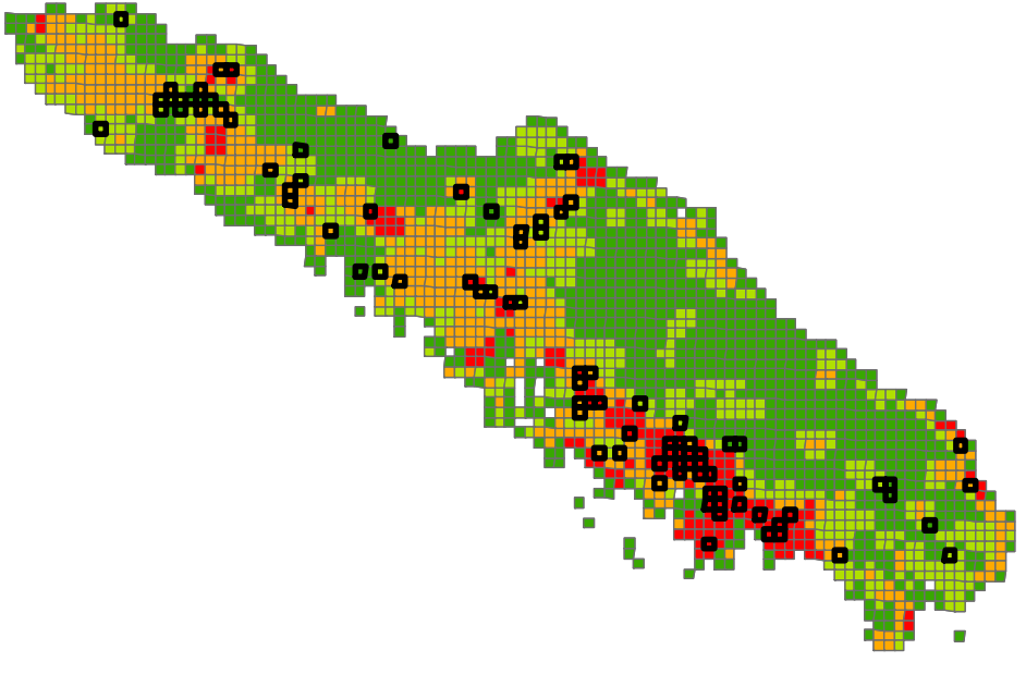
Pioneering study combining satellite remote sensing (NOAA AVHRR, MODIS) and multi-criteria GIS analysis to map wildfire risk across Province Sud and prioritise the protection of sensitive natural habitats.
Context
In 2005, the Directorate of Natural Resources of Province Sud (Environment Department) commissioned Yann-Eric Boyeau — today founder and director of MAGIS — to cross-reference wildfire threat with the ecological priority map established in the first phase of the study. The goal: understand where and why bushfires start, then identify the priority natural habitats to protect.
At the time, no reliable, centralised database recorded fires across the territory. It was therefore necessary to rebuild a usable data source from several disparate origins: satellite archives, civil security records, and water-bomber helicopter intervention reports.
Methodology
Recovery and processing of satellite archives
- Searching and re-reading raw NOAA AVHRR archives (1997-2002) stored on DDS1 magnetic tapes, using a drive reconstituted on an old Unix workstation, as the original equipment was no longer in service;
- Writing a decompression script for the raw 10-bit data frames, and rebuilding the georeferencing chain (navigation, geometric/radiometric correction to L1B level) using the HrptReader software;
- Diagnosing archived data from 1998-2002, whose detection algorithm produced aberrant results (tens of thousands of false positives per image, fires detected at sea) — a critical analysis revealing the likely origin of these artefacts (channel saturation, cloud cover);
- Exploiting the MODIS Fire archives (NASA / University of Maryland, 2000-2005), offering more reliable detection at kilometre-scale precision.
Spatio-temporal analysis of fire outbreaks
- Annual, monthly and daily distribution of detected fires, highlighting a seasonal peak (October-December) and a predominantly human origin (uneven distribution across days of the week);
- Geographic analysis by municipality and by watershed (identifying the most affected areas: Néra, Thio, Île des Pins);
- Proximity statistics: distance to towns/tribal settlements, to buildings (BDTOPO), and to access roads, revealing that 80% of fires start within 1 km of a road;
- Kernel density mapping to visualise the spatial intensity of the phenomenon.
Risk modelling and cross-referencing with ecological priorities
- Setting up a DFCI grid (2 km cells, mainland French standard) to structure the entire analysis at a scale compatible with the precision of available data;
- Building a multi-criteria risk index per DFCI cell, combining housing density, proximity to the road network and annual rainfall, each parameter reclassified according to its observed fire occurrence;
- Cross-referencing wildfire risk with the botanical/faunal conservation priority map (from the first part of the study) to produce a priority action map distinguishing four zone profiles (to monitor, to protect, no stakes, threat to reduce).
Results & key figures
Overall wildfire risk turns out to be up to 80 times higher between DFCI cells classed “very high” (24.9 fires / 400 km²) and those classed “low” (0.3 fires / 400 km²).
- 80% of fire outbreaks occur within 1 km of a building and within 1 km of an access road;
- 50% of fires are detected within 5 km of a town or tribal settlement;
- Priority areas identified: the far South, the peri-urban fringes of Païta and Dumbéa, the Bourail–Poya coastline, the Thio transversal, the Col d’Amieu, and Île des Pins;
- Recommendation to set up a Prométhée-type database for the long-term, centralised recording of fires — the DFCI grid produced during the study went on to serve as a common location standard for civil security, gendarmerie and provincial services.
Tools & data used
| Source / Tool | Purpose |
|---|---|
| NOAA AVHRR (1997-2002 archives) | Historical fire detection via thermal remote sensing |
| MODIS Fire (NASA / Univ. of Maryland, 2000-2005) | Hotspot detection, kilometre-scale precision |
| HrptReader | Decoding and georeferencing of raw satellite imagery |
| BDTOPO DITTT | Location of buildings and the road network |
| DFCI Grid (2 km) | Reference grid for the multi-criteria risk analysis |
| Multi-criteria GIS analysis | Wildfire risk modelling and weighting |
This study laid methodological foundations — remote sensing, multi-criteria spatial analysis, cross-referencing of stakes — that MAGIS still applies today to risk management and environmental monitoring challenges. See for example our cyclone and wildfire monitoring suite for DSCGR.